

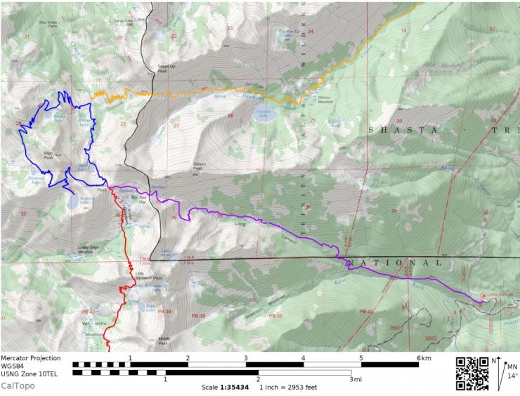
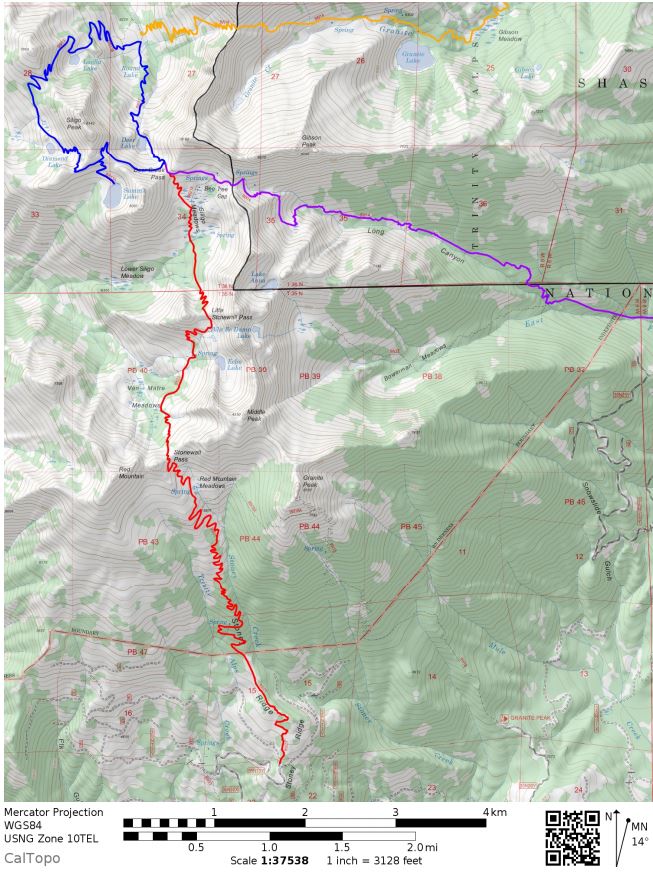
Trip overview: The Four Lakes Loop is a ~20 mile out and back backpacking trip from the Long Canyon Trailhead in the Trinity Alps Wilderness area. A 5.7 mile one-way hike gets you to the Four Lakes Loop Trail, which is a ~6 mile loop connecting four alpine lakes within a beautiful area of the Trinity Alps. +/- 6,000 feet with a starting elevation of 3,760 feet and a peak elevation of 7,760 feet. Several side trips are possible to add variety and additional mileage. Highlights include alpine lakes, meadows, and multi-colored mountain peaks.
- Overall map of Four Lakes Loop Trek (pdf)
Jump to Day 1: Long Canyon Trailhead to Deer Lake (or Summit Lake)
Jump to Day 2: Hiking the Four Lakes Loop
Jump to Day 3: Potential side trips
Jump to Day 4: Deer Lake (or Summit Lake) to the Long Canyon Trailhead
Jump to: Alternate routes to the Four Lakes Loop
Shop Sale & Clearance Items at REI.com (up to 50% off)!
Preparations:
Permits: You will need a Wilderness Permit to camp in the Trinity Alps Wilderness and need a California Campfire Permit in order to have any camp fires. Luckily, there are no quotas in place limiting the number of permits, so you can backpack in the Trinity Alps without needing to reserve a permit well in advanced of your trip. Both the camping and fire permits are free and can be picked up at the Weaverville Ranger Station in Weaverville, CA. If you arrive when the ranger station is open, you can go inside get your permits and talk to the rangers. If you arrive when the station is closed, there is a self-service kiosk outside where you can fill out a permit and drop it in a lock-box. You can find some basic information about the wilderness and permits at the National Forest webpage for the Trinity Alps.
For information on current conditions, your best bets are to either call the ranger station (530-623-2121) or to visit the Trinity Alps Wilderness facebook page. I found the facebook page to be the most useful because many people were posting pictures and descriptions of the treks they did the previous weekend. There are only a handful of rangers covering the whole wilderness area, so they are not able to check out all the trails on a regular basis.
Logistics: Since you can grab permits at the self-service kiosk at the Weaverville Ranger Station, you do not need to worry about arriving when the ranger station is open (unless you want to ask the ranger questions). After getting your permit, you will have to drive to the trailhead because there are no shuttles or buses. Parking at some of the popular trailheads can get crowded, but if you arrive early and beat the day hikers, you should not have a problem.
The Four Lakes Loop can be reached via several different trails. In this itinerary I will primarily describe the route along the Long Canyon Trail. Alternatively one could hike the Stoney Ridge Trail or the Swift Creek Trail. I will briefly talk about these alternative trails at the end of the report, but will not go into much detail. All three trails have a fair amount of elevation gain, so plan to hike at a rather slow pace.
Supplies: You will need to either store your food in a bear canister (Bear Vault BV500 transparent canister) or bring supplies to hang your food at night (Liberty Mountain Ultralight Bear Bag
). Bears in the Trinity Alps are not as mischievous as the bears in Yosemite or Sequoia, but follow the rules and protect your food so the bears do not develop bad habits. I prefer the bear canister because I use it as a chair. There also are not many trees to hang food in on this loop, so the canister is the best option.
There are a fair number of mosquitoes near the lakes and in the meadows, so treating your clothes and tent with permethrin repellent is a good idea. I also like to use a picaridin-based bug spray
on my exposed skin.
The trail is quite steep in many areas, so you will want trekking poles to help save your knees. Some areas of the loop can have snow on them if you go early in the season. If this is the case, you may want to brings some microspikes/crampons.
Below is a list of the gear suggested for this type of trip in the Trinity Alps:
Hiking clothes
- a lightweight hiking rain jacket (North Face Venture 2 Jacket)
- fast drying synthetic hiking pants (prAna Zion Pants)
- a quick drying long sleeve hiking shirt (Columbia Silver Ridge L/S Shirt)
- wool outer socks (People Socks Moreno 4-pack)
- thin blister preventing base socks (WrightSock double layer Coolmesh)
- quick drying synthetic boxer briefs (ExOfficio Give-N-Go)
- Gore-tex hiking shoes (adidas Outdoor Terrex Fast R Gore-Tex Shoe)
Clothes for camp
- wool leggings (Minus33 Merino Wool Kancamagus Midweight Bottom)
- wool base layer shirt (Minus33 Merino Wool Chocorua Midweight Crew)
- warm wool overshirt (Pendleton Long Sleeve Classic-Fit Board Shirt)
- lightweight down jacket (Patagonia 800-fill Down Jacket)
- lightweight camp shoes (Xero Z-Trail lightweight sandal)
Hiking gear
- trekking poles (Black Diamond Trail Ergo Cork Trekking Poles)
- 2 liter hydration bladder (Platypus Big Zip Water Reservoir)
- 65 liter backpack (Osprey Atmos 65 Liter pack)
- water filtration system (Platypus gravity filtration system)
Camp gear
- strong tent with rain-fly (Alps Mountaineering Chaos 2 Tent)
- inflatable sleeping pad (Therm-a-Rest Trail Pro Sleeping Pad)
- sleeping bag (REI Co-op Igneo 25 Sleeping Bag)
- inflatable camping pillow (Ultralight Inflating Pillow)
- lightweight backpacking chair (Helinox Chair Zero)
- lightweight lantern (MPOWERD Luci Outdoor 2.0)
- headlamp (Black Diamond Cosmo Headlamp)
- multi-tool with knife (Gerber MDime Mini Multi-Tool)
- Ursack (Ursack Major bear bag) or bear canister (BearVault BV500)
- lightweight stove (MSR PocketRocket 2)
- lighter (BIC plastic lighters)
- 2 liter pot (GSI Outdoors Halulite Boiler Pot)
- coffee cup (GSI Outdoors Glacier Stainless Cup)
- lightweight spork (Snow Peak Titanium Spork)
- small, quick drying towel (REI mutli towel mini)
Random
- wet wipes (Stall Mates individually wrapped wipes)
- mole skin for blisters (Blister medic kit)
- lightweight trowel (GSI Sanitation Trowel)
- small amount of duct tape for gear repairs
- chapstick and sun screen
Food and drink
- a variety of my favorite dehydrated meals
- electrolyte replacement (NUUN Hydration Tablets)
- quick snacks (Clif Shot Bloks and Clif energy bars)
- instant coffee (Starbucks VIA)
- small plastic water bottles filled with whisky 🙂
Weather and Trail Conditions: The trail is fairly easy to follow and is well-maintained. If you are backpacking in the middle of the summer, be prepared for warm temperatures and also check that there are no forest fires in the area. It can easily get up to the 90s in the forest during the middle of the day because the Trinities are lower altitude compared to the Sierras. There can also be afternoon thunderstorms. If you go earlier in the season, be sure to check current conditions and make sure the snow has melted.
Difficulty: The trails in the Trinity Alps are typically very steep with lots of elevation gain, and this trail is no exception. Expect to be hiking up and down a lot. Luckily the Four Lakes Loop is only ~6 miles from the Long Canyon Trailhead, so the overall mileage is limited. If you plan to cover more ground than is shown in this itinerary, be prepared for tough hikes and many switchbacks in the Trinity Alps. The views are often beautiful, but that trails make you work hard.
………..
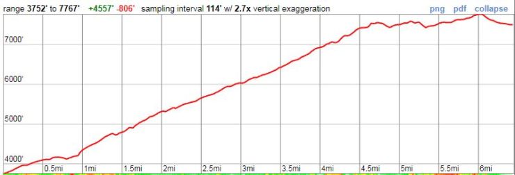
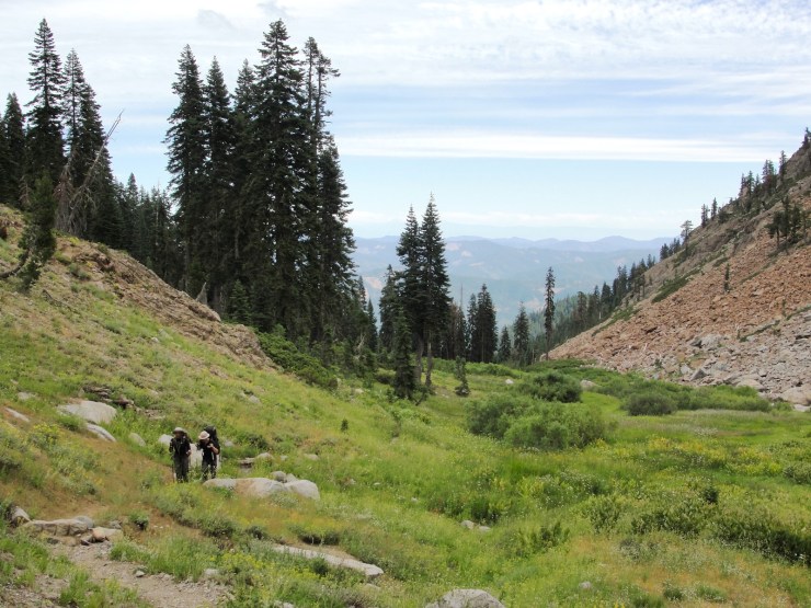
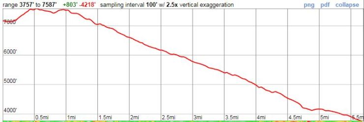
Day 1: Long Canyon Trailhead to Deer Lake (or Summit Lake); 5.7 (6.5) miles; +4,220 / -800 (+4,560 / -800) feet
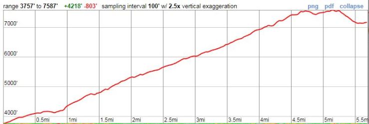
The Long Canyon Trailhead is located off of Long Canyon Road about a 10 minute drive in from Highway 3. There is a sign on Highway 3 at the turnoff that notes the entrance for the Long Canyon Trail. In total, the trailhead is about a 40 minute drive from the Weaverville Ranger Station. If you wish to car camp the night before starting your trek, there are several forest service campsites in the vicinity of Trinity Lake and the trailhead.
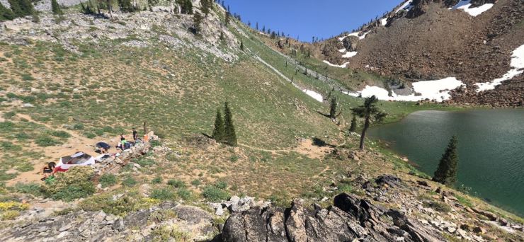
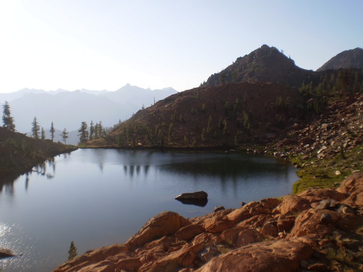
At this point you must decide to either head to the right and work your way down to Deer Lake or to head left and continue to either Summit Lake or Diamond Lake. There are campsites at all three of these lakes and there are also campsites in the meadow areas near the Four Lakes Loop. Deer Lake is the most popular lake to camp at and has a few developed campsites. Summit Lake is nice as well and is a bit more sheltered than the other lakes. Diamond Lake has spectacular views but has only a couple places to camp. Some photos of campsites at the lakes are shown below. If you have a large group or want to avoid crowds, it may be wise to avoid camping at one of the lakes and to camp by Siligo Meadows or somewhere by Deer Creek.
After all the climbing on the first day, you will likely just set up camp and relax the rest of this day. If you wanted to catch a great sunset on this night, you could make your way to Diamond Lake.
………..
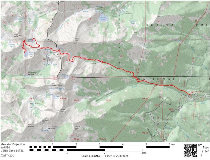
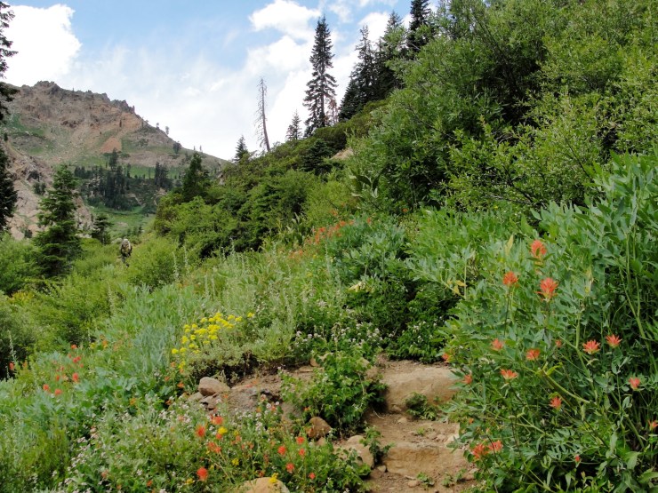
Day 2: Hike around the Four Lakes Loop; 6 miles; +/- 2,300 feet
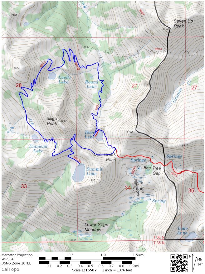
Map of the Four Lakes Loop (PDF)

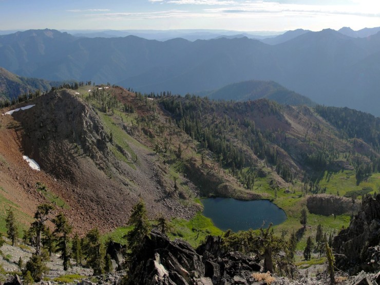
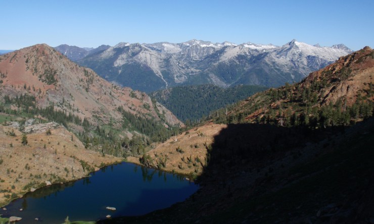
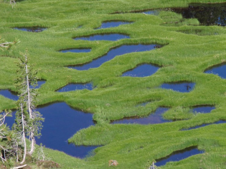
On this day, it is easiest to leave your large backpack behind and hike the Four Lakes Loop with just a day pack. The loop is only 6 miles long but has plenty of switchbacks. Along the way you can make several side trips to add mileage if need be. These include scrambling to the top of Siligo Peak, hiking up to the summit of Seven Up Peak, or making longer trip to Echo Lake. Alternatively you could just hike the Four Lakes Loop and explore the areas around each of the lakes (Deer Lake, Summit Lake, Diamond Lake, and Luella Lake).
Most hikers go around the Four Lakes Loop in the clockwise direction because this provides some great views. The following photos show scenes from the Loop in the clockwise direction starting from near Deer Creek Pass.

………..
Day 3: Potential side trips from the Four Lakes Loop
Summit of Siligo Peak – The off trail hike to the peak of Siligo Peak starts from the portion of the Four Lakes Loop near the turn off for Summit Lake. The sidetrip to the peak is ~0.6 miles and +/- 400 feet round trip. At the top of the peak you get great views of the surrounding area.

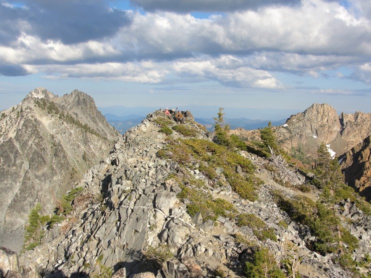

Summit of Seven Up Peak – This side trip provides nice views of the Deer Creek Valley, Four Lakes Loop, Bear Basin, and Granite Creek area. The hike is longer and more strenuous than that for the Siligo Peak trip, but still no technical climbing is required. The side trip to the summit of Seven Up Peak is about 4.3 miles and +/- 2,100 feet round trip from the junction with the Four Lakes Loop near Deer Creek.
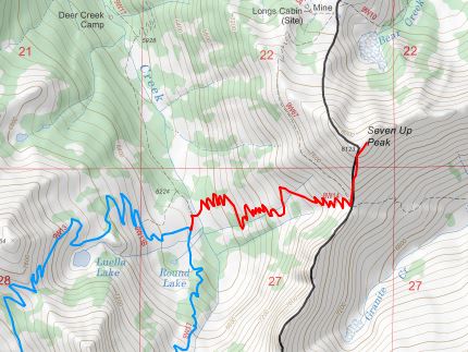

More info on this side trip can be found on the summitpost page.
Echo Lake – The side trip to Echo Lake could be done as a day trip or you could even hike over and set up camp here for a night. From Deer Lake the trip is 5 miles and +/- 2,400 feet round trip. Along the way you pass through Lower Siligo Meadows, can catch views of nearby Van Matre Meadows, and get to see the scenic Echo Lake at the end.

………..
Day 4: Deer Lake to Long Canyon Trailhead; 5.7 (6.5) miles; +800 feet / -4,200 (+800/ -4,560) feet
This hike is just backtracking along the Long Canyon Trail back to the trailhead. Unfortunately it is not possible to make a nice loop with no backtracking in area of the Trinity Alps. If you did not want to take the whole Long Canyon Trail back, you could do a little off-trail hiking and exit via Bowerman Meadows. This trail would involve going from Deer Creek Pass to Siligo Meadows to Echo Lake to Billy Be Damn Lake to Bowerman Meadows and back to the Long Canyon. Note that the section between Echo Lake and Bowerman Meadows would be off trail hiking.

………..
Alternate trails to the Four Lakes Loop
The hike in from the Stoney Ridge Trailhead is arguably the most scenic route to the Four Lakes Loop. However, this route is less popular than the Long Canyon Trail route because of its length and steep, steady climb. That said, you can camp at Echo Lake along the way in at the ~6 mile mark to break the hike up. The Stoney Ridge Trail is a great option if you are a strong hiker or have an extra day to camp at Echo Lake before reaching Deer Lake. Along this trail you get great views from Stonewall Pass and Little Stonewall Pass and you hike through Van Matre Meadows and both Lower and Upper Siligo Meadows.
Map of hike in from Stoney Ridge Trailhead (PDF)
The third route one can take to the Four Lakes Loop is the Swift Creek Trail. This trailhead is the furthest North and is quite long to get to Deer Lake. Along this route you have the opportunity to visit and/or camp at Granite Lake.

Map of hike in from Swift Creek Trailhead (PDF)
Here are some similar trip reports!
Trinity Alps Wilderness – Emerald and Sapphire Lakes

Thank you writing this page, I would like to hike this loop, but worry about crowds. Did you see a lot of other people?
LikeLike
Hi George – If you do the Four Lakes Loop on a weekend, you are likely to encounter some other hikers. This will be especially true this summer as many other backpacking areas are very snowy. I could see there being more traffic in the Trinity Alps as people try to avoid the snow. The area is still beautiful though! I wouldn’t let the crowds discourage you.
LikeLike
There was definitely people on the four lakes loop however we never saw a single soul when we approached from Stoney Ridge. We camped at Echo lake the first night and it was amazing. We had the lake to ourselves.
LikeLike
Thank you so much for this guide! Going to do this in July – Long Canyon to Summit Lake, then to Deer Lake, and then back to the trailhead. Hard to find much information on this trail, so this is super helpful!
LikeLike
Awesome – Hope you have a great trip!
LikeLike
Great detailed write up! Thanks. Love the photos and the commentary. Didn’t see a date for this trip. Did you go up this year (2019)? We were planning on going up this weekend but heard the snow was still blanketing the trails as of a week ago.
LikeLike
Hi Diana – we actually went on this hike a few years ago at the tail end of the drought. The pictures are not indicative of the current conditions. Probably a good amount of snow still covering the trail near the four lakes! The Trinity Alps facebook page (https://www.facebook.com/trinityalpswilderness1984/) sometimes has recent photos of the trails. I would check there and/or call up the ranger station.
LikeLike
Ahh, I figured, but held out hope given the recent comments haha! Thank you for the clarification.
LikeLike
Anyone do this hike this spring/summer (2019)? I’d love to hear about trail conditions (snow, washouts, road to trailhead). Thanks!
LikeLike
My sister and I attempted this trail early June, snowed in couldn’t get to deer lake even. We are attempting it again this weekend July 26th. fingers crossed that most of the snow is gone!
LikeLike
Awesome, let us know how it goes! The Four Lakes Loop area looks mostly snow free in the latest weekly satellite images, so you should be good to go.
LikeLike
My wife and I plan to do this hike Aug 2-4. If anyone would like to “buddy up” so we can hike in via Stoney Ridge and out Long Canyon (or vice versa) Please get in touch with me (8015051404. I’m envisioning a car shuttle.
LikeLike
Thank you so much for this guide! I’m planning on doing this trip in a couple weeks. Any recs on where to car camp Friday before hitting the trail sat am?
LikeLike
Hi Hayley – There are a handful of campgrounds on Highway 3 on the west side of Trinity Lake. You may be able to reserve a site or do first come-first served camping at one of those. We stayed at the Minersville Campground the night before one of our trips and it was convenient. Check out recreation.com and search for campgrounds in Shasta-Trinity National Forest. Good luck!
LikeLike
going aug 9, 2023 6 lake loop,7 .anna first ,welcome to come with me,
LikeLike