


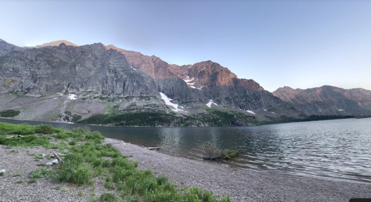
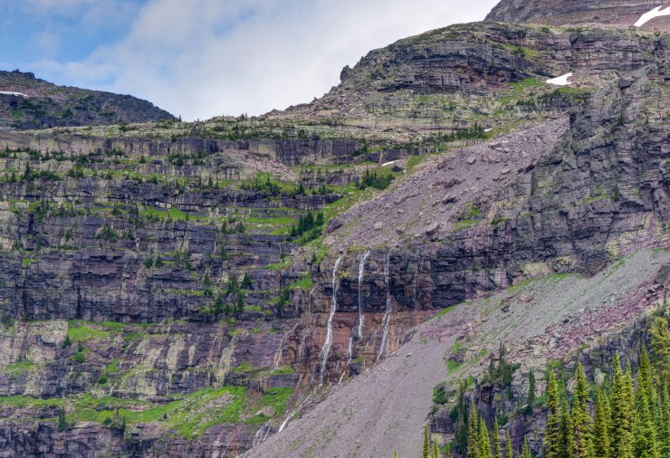
Trip Overview: The Gunsight Pass to Lake McDonald backpacking route traverses ~22 miles within Glacier National Park. Along the route you hike over Gunsight Pass and Lincoln Pass as you cross the Continental Divide. You also pass by several beautiful lakes including Saint Mary Lake, Gunsight Lake, Lake Ellen Wilson, and the famous Lake McDonald. This route has a peak elevation of 7,060 feet and you climb roughly 4,000 vertical feet over the course of the 22 mile trek. Highlights of this itinerary include massive mountains, the nearby Sperry Glacier, wildflower blooms, alpine lakes, waterfalls, and abundant wildlife. The majority of the images in this report are from a trip in August of 2012 (captured by John Strother).
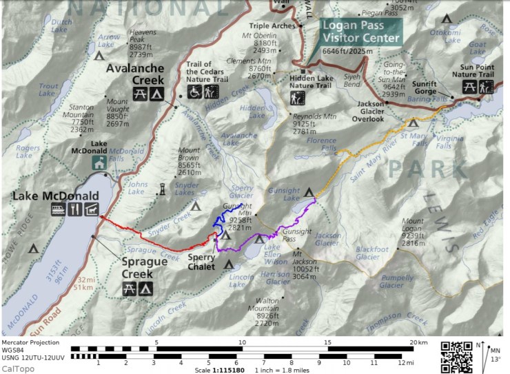

- Overall map of the Glacier Gunsight Pass to Lake McDonald Route (PDF)
Jump to Day 1: Saint Mary Lake to Gunsight Lake Campground
Jump to Day 2: Gunsight Lake to Sperry Campground
Jump to Day 3: Sperry Campground to Lake McDonald
Jump to Sidetrip: Hike to the Sperry Glacier
Shop Sale & Clearance Items at REI.com (up to 50% off)!
Preparations:
NOTE: The National Park Service has made many changes to their services and policies in response to the COVID-19 pandemic in 2020. Please check the NPS website for the most accurate information since policies are changing frequently.
Click here to read more about Permits
Permits: Glacier National Park is one of the most popular backpacking and hiking destinations in the United States, so permits are required for overnight camping and the number of permits issued for each day is limited. You will want to secure a permit as early as possible to do this hike if going in July, August, or early September. The peak hiking season is generally mid July through early September and many trailhead quotas fill up very early for these dates.
Approximately half of the wilderness permits for each backcountry campground are available for advanced reservation and the remaining half are saved for first-come, first-serve walk ups (you may line up at the permit station starting at 4:00am the day before your hike). If you are lucky enough to get a walk up wilderness permit, you will pay $7 per person per night in camping fees. To see available walk-up availability for today check here. Note that dispersed backcountry camping is not allowed in most areas of Glacier National Park, so your permit will specify your camping location for each night of your trip.
The best way to secure a wilderness permit is to submit a wilderness permit application for the permit lottery. Advanced reservations are available for itineraries with start dates between June 15 – September 30. To be considered in the permit lottery, you must submit your permit application between 12:00am MST and 11:59pm MST on March 15 (this was the date for 2019, but it may change slightly for future years). All applications submitted within that time frame are processed in a random order. Any applications submitted after the lottery window are processed in the order they are received. Permit applications must be submitted online (info here) and there is a non-refundable $10 administrative fee and $30 fulfilled trip request fee (refunded if you do not receive a permit). Standard group sizes are limited to 1-8 campers and for advanced reservations you are limited to hiking less than 16 miles on any given day of your proposed itinerary (this distance limit does not apply to people seeking walk-up permits).
On your application you will list your proposed trip date, entry/exit trailheads, and campsites for each night. You are encouraged to submit an alternative itinerary in case your first choice is not available. For the specific itinerary described in this report, you will enter the wilderness at the Saint Mary Falls shuttle stop. Your first night of wilderness camping is spent at the Gunsight Lake Campground (GUN). The second night of camping is at the Sperry Campground (SPE) and then you exit the route at the Lake McDonald Lodge. A map showing the names and locations of the backcountry campsites is found here.
If you are able to reserve a permit and pay your fee, the next step is to pick up the physical permit the day before or the morning of your hike. You can get the permit at the Apgar Backcountry Permit Center or at one of the various Glacier National Park ranger stations. These are typically open daily from late May to late September. If you are delayed and cannot pick up your permit the morning of your hike, call the ranger station and see if they can hold your permit for you. Otherwise, your permit will be released to the general public and will likely be taken by a walk-up permit seeker. It is typically wise to plan to arrive the day before your trek is schedule to start so that you have ample time to pick up your permit at the ranger station.
Click here to read more about Logistics
Logistics: To get to Glacier National Park, it is most common to drive. Visitors either road trip all the way to the park or fly into a nearby airport, rent a car, and drive to the park. Flights into Kalispell Glacier Park International Airport (FCA) or Great Falls International Airport (GTF) are typically available with one stop from most major airports. Many Glacier Campground is a ~3 hour drive from both airports. Once you are inside the park, there is a shuttle system that can be utilized.
If you would like to camp at one of the developed campsites within Glacier National Park the night before your trek, you will need to either get an advanced reservation or arrive early in the morning to try to secure a walk-up spot. There are several campgrounds in Glacier and more info on each can be found here. Note that all the campgrounds are popular in the summer, so you may need to reserve sites well (>6 months) in advance. Unfortunately this means you may need to reserve a campsite before you know whether or not you have received a wilderness permit.
The easiest way to complete the Gunsight Pass to Lake McDonald route is to take advantage of the Glacier National Park shuttle system. More information about the shuttle routes can be found here. You can choose to either take the shuttle the morning before starting your backpacking trek (park at the Lake McDonald Lodge and shuttle to Saint Mary Lake before setting off) or to take the shuttle once you finish the route (park at Saint Mary Lake and take the shuttle from Lake McDonald back to Saint Mary Lake after finishing). The advantage of taking the shuttle at the start is that your vehicle is waiting for you at the end of the route and you can immediately drive off. The disadvantage of taking the shuttle before your trek is that the shuttle schedule will likely cause you to have a later start to your hike than you may prefer. Luckily you do not cross any mountain passes on the first day of this trek, so a late start is not too problematic.
Click here to read more about Weather and Trail Conditions
Weather and Trail Conditions: It is important to check the trail conditions before taking off on this trek. You can find reports on trail and wilderness conditions here. The main concerns for this itinerary are the status of the seasonal bridges placed along the route. If these are not in place, you will need to speak to the rangers and assess the safety of fording the streams/rivers. You will also want to ensure that the trail is free of snow drifts at the two passes. If conditions are still snowy at high elevation, rangers may recommend that you bring an ice ax and crampons (and know how to use them).
The weather in Glacier National Park during the peak hiking season (July, August, and September) is characterized by warm days, cool nights, and occasional thunderstorms. When a storm rolls in, it is not uncommon for the temperature to drop quickly. Thus, you must be prepared for a wide range of temperatures (32-85 degrees F). Late in the season (late September-October), it is not uncommon for it to snow at high elevation. If you plan to complete the trek in late September or October, you must be prepared for rapidly changing weather and be comfortable hiking in snow. In the prime hiking season (late July through early September), the weather is typically good, but be mindful to avoid exposed, high elevation areas in the afternoon when brief storms frequently occur. Given that weather can change rapidly in the mountains, you should be prepared with different layers of clothing for different conditions.
Click here to read more about Difficulty
Difficulty: The Gunsight Pass to Lake McDonald route in Glacier National Park is a moderate trip. When backpacked over the course of 3 days, this route is very manageable for backpackers with some previous experience. The second day where you hike over Gunsight Pass and Lincoln Pass will be the most difficult day with ~3,000 feet of climbing. Note that this assumes the snow has cleared from the trail at high elevation and assumes that all seasonally installed bridges are in place. If you must ford rivers and cross snow fields, the level of difficultly increases.
Supplies: In Glacier National Park, you must be prepared for a variety of conditions depending on the time of year. Up until late July, snow often remains in the high country and on mountain passes. If you are hiking this loop in June or July (before the snow fully melts) or in late September (when snow can begin to fall again), you will want to consider bringing microspikes/crampons and an ice ax. However, if the trail is clear of snow, then these are not needed.
Because of rapidly changing weather in the mountains, you will want to bring several layers so that you can easily adapt to the changing temperature and also so that you can stay dry. I also recommend having a set of wool clothes to change into at camp. Wool is great because it doesn’t pick up funky stenches as fast at cotton or synthetic clothes. It also dries out quickly so that you are able to stay warm even if all your gear gets soaked in a thunderstorm.
Other specific gear you will want for backpacking in Glacier National Park is related to bear safety. The park is inhabited by both grizzly and black bears. Thus, it is essential to store all food and scented items in a bear canister or to hang food properly at the campsites. For hanging, it is recommended to bring a weatherproof food bag and 25 feet of rope. It is also highly recommended for every member of your party to carry bear spray.
You may also want to pre-treat your clothes and tent with permethrin spray repellent. Doing so helps keep mosquitoes and other bugs away and reduces the amount of DEET or picaridin spray you need to carry. The permethrin treatment stays on your clothes for up to 7 washes.
Below is a list of the gear recommended for backpacking in Glacier National Park:
Hiking clothes
- a lightweight hiking rain jacket (North Face Venture 2 Jacket)
- fast drying synthetic hiking pants (prAna Zion Pants)
- a quick drying long sleeve hiking shirt (Columbia Silver Ridge L/S Shirt)
- wool outer socks (People Socks Moreno 4-pack)
- thin blister preventing base socks (WrightSock double layer Coolmesh)
- quick drying synthetic boxer briefs (ExOfficio Give-N-Go)
- Gore-tex hiking shoes (adidas Outdoor Terrex Fast R Gore-Tex Shoe)
Clothes for camp
- wool leggings (Minus33 Merino Wool Kancamagus Midweight Bottom)
- wool base layer shirt (Minus33 Merino Wool Chocorua Midweight Crew)
- warm wool overshirt (Pendleton Long Sleeve Classic-Fit Board Shirt)
- lightweight down jacket (Patagonia 800-fill Down Jacket)
- lightweight camp shoes (Xero Z-Trail lightweight sandal)
Hiking gear
- topographic map (National Geographic Many Glacier Map)
- trekking poles (Black Diamond Trail Ergo Cork Trekking Poles)
- 2 liter hydration bladder (Platypus Big Zip Water Reservoir)
- 65 liter backpack (Osprey Atmos 65 Liter pack)
- water filtration system (Platypus gravity filtration system)
Camp gear
- strong tent with rain-fly (Alps Mountaineering Chaos 2 Tent)
- inflatable sleeping pad (Therm-a-Rest Trail Pro Sleeping Pad)
- sleeping bag (REI Co-op Igneo 25 Sleeping Bag)
- inflatable camping pillow (Ultralight Inflating Pillow)
- lightweight backpacking chair (Helinox Chair Zero)
- lightweight lantern (MPOWERD Luci Outdoor 2.0)
- headlamp (Black Diamond Cosmo Headlamp)
- multi-tool with knife (Gerber MDime Mini Multi-Tool)
- Ursack (Ursack Major bear bag) or bear canister (BearVault BV500)
- lightweight stove (MSR PocketRocket 2)
- lighter (BIC plastic lighters)
- 2 liter pot (GSI Outdoors Halulite Boiler Pot)
- coffee cup (GSI Outdoors Glacier Stainless Cup)
- lightweight spork (Snow Peak Titanium Spork)
- small, quick drying towel (REI mutli towel mini)
- bear spray (Frontiersman max range bear spray)
Random
- wet wipes (Stall Mates individually wrapped wipes)
- mole skin for blisters (Blister medic kit)
- lightweight trowel (GSI Sanitation Trowel)
- small amount of duct tape for gear repairs
- chapstick and sun screen
Food and drink
- a variety of my favorite dehydrated meals
- electrolyte replacement (NUUN Hydration Tablets)
- quick snacks (Clif Shot Bloks and Clif energy bars)
- instant coffee (Starbucks VIA)
- small plastic water bottles filled with whisky 🙂
……….
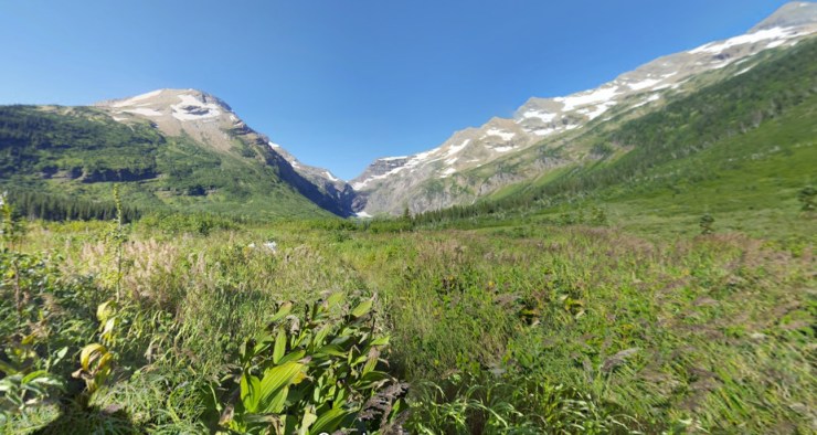
Day 1: 8.5 miles; +1,350 feet / -770 feet; Saint Mary Lake to Gunsight Lake Campground

Glacier National Park, Gunsight Pass Day 1 map (PDF)

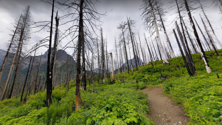
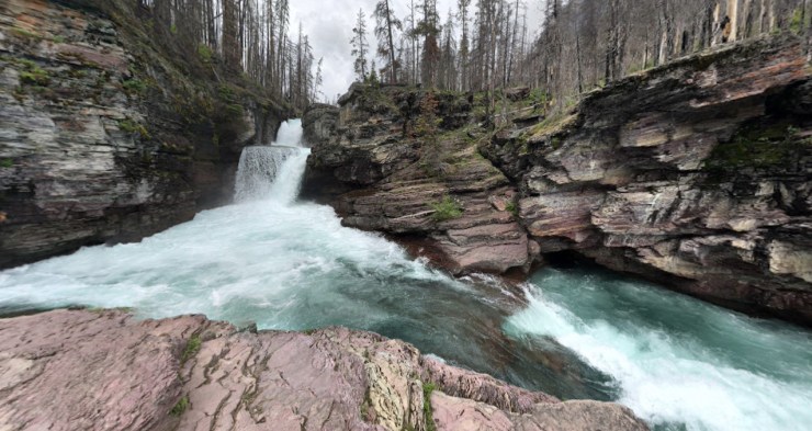
On the first day of this trek you hike from Saint Mary Lake to the Gunsight Lake Campground. Along the way you can take short side trips to see Saint Mary Falls and Florence Falls. Depending on your preference, this day will either start with a shuttle ride to the Saint Mary Falls shuttle stop (if you parked at the Lake McDonald Lodge) or with you driving and parking near Saint Mary Lake.
The first day’s hike is of modest difficulty with only ~9 miles of hiking and ~1,000 feet of elevation gain. The Gunsight Lake Campground has several sites and great views of Gunsight Lake are very close by. You start the trek on the Piegan Pass Trail. Shortly before the mile mark, there is a side trail you can take to view Saint Mary Falls. You continue on the Piegan Pass Trail until about the 2 mile mark. From there, you take the Gunsight Pass Trail west all the way to the Gunsight Lake Campground. Near the 6 mile mark, there is another side trail that leads to Florence Falls.


……….
Day 2: 7.0 miles; +3,100 feet / -1,890 feet; Gunsight Lake to Sperry Campground

Glacier National Park, Gunsight Pass Day 2 map (PDF)
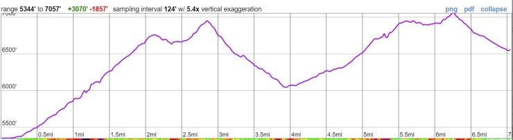
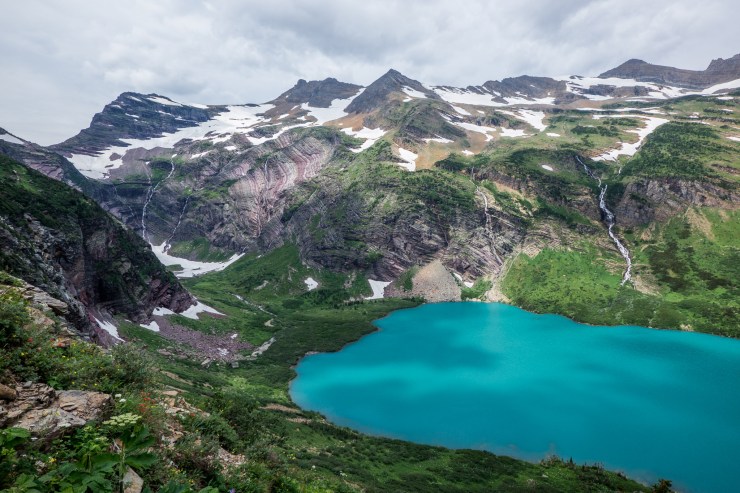
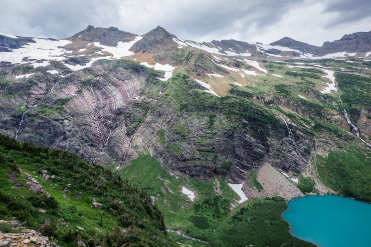
The hike on the second day takes you up over Gunsight Pass and Lincoln Pass. Between these two passes, you skirt by beautiful Lake Ellen Wilson. This hike is the most beautiful section of the trek, but also has the most elevation gain at ~3,000 feet over the course of 7 miles.
You start the hike continuing west on the Gunsight Pass Trail. Shortly after leaving camp, you cross the outlet at the east end of Gunsight Lake. There is usually a bridge installed here during hiking season, but check with the rangers before your hike to verify. After crossing the bridge, you start a 3 mile trek up to Gunsight Pass. The pass sits at 6,950 feet and provides some great views of the surrounding area. The trail then drops ~1,000 feet down to Lake Ellen Wilson and climbs another 1,000 feet back up to Lincoln Pass. At the top of Lincoln Pass, you have the option to climb ~0.25 miles and 400 feet up to the summit of Lincoln Peak where you get some great views. From the top of Lincoln Pass, the Sperry Campground is only ~1 mile downhill.


……….
Day 3: 6.3 miles; +155 feet / -3,490 feet; Sperry Campground to the Lake McDonald Lodge

Glacier National Park, Gunsight Pass Day 3 map (PDF)

The last days hike is a relatively easy downhill trek to the Lake McDonald Lodge. From there you either catch the shuttle back to your car, or get in your car and drive home! You are treated to some nice views of Lake McDonald along the way.
On this day, you have the option to do a significant side trip up to the Sperry Glacier. This trek is roughly 6-7 miles round trip and climbs ~2,000 feet. There are also some large snow fields you may have to cross. If you want to do the side trip, it may be wise to consider camping two nights at Sperry!


……….
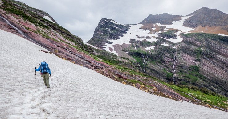
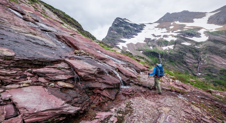
Side trip: 6.3 miles; +/- 1,940 feet; Sperry Campground to the Sperry Glacier (and back)

Glacier National Park, Gunsight Pass Sperry Glacier map (PDF)

The trail up to the Sperry Glacier passes by a few lakes and crosses several snow fields en route to the glacier. The snow fields are permanent, so plan to follow foot steps and cairns in sections. If you complete the trip though, you are rewarded with the opportunity to see the views and glacier up close!
The trail starts in Glacier Basin. From there you climb steadily up to Comeau Pass. There are some very nice views at the pass, so take a break and look around. After the pass you will largely be following cairns and crossing snowfields on your way to Sperry Glacier. This site has some great photos and a description of the route.


Here are some similar trip reports!
North Circle Loop – Glacier National Park (52 mile loop)
Teton Crest Trail – Grand Teton National Park (48 mile loop)
Cirque of the Towers Loop – Wind River Range, WY (45 mile loop)
Four Pass Loop – Maroon Bells Snowmass Wilderness, CO (28 mile loop)
